St. Helens US 30 Corridor Plan

This large-scale planning project involves planning for both a state highway and main street urban streetscape. The goal of the Highway 30 project is to provide safe, convenient access to local businesses along the highway, while balancing that with state goals for traffic mobility. GreenWorks is providing design and planning overview for this project.

US 30 StHelens_Page_13.jpg

Sandpoint Downtown Streetscape

roundabout schematic design showing stormwater features as cars circulate

GreenWorks developed green street schematic design concepts for the City of Sandpoint, Idaho, which will serve as a green street pilot project for the City of Sandpoint. Concepts for these existing streets looked at different options for how to retrofit green infrastructure to work with different existing conditions and how the design would fit with the character of the neighborhoods. Some of many issues considered in the designs were preserving existing mature trees, ease of snow plowing operation, on-street parking, vegetated stormwater facility types and pedestrian circulation.

Oregon City Warner Milne Rain Garden

As part of the realignment of Warner-Milne Road at the Molalla Avenue intersection, the City of Oregon City hired a team with GreenWorks to design a rain garden in a vacated portion of the right-of-way that will treat stormwater runoff from the adjacent heavily-travelled roadways. A series of large serpentine Corten steel fins meander through the site, articulating the stormwater channel and creating a striking contrast to the lush rain garden plantings. The first of its kind in Oregon, this rain garden incorporates prominent sculptural elements that highlight the City’s committment to sustainability.

Warner_Milne_Rain_Garden.jpg
warnermilneraingarden_website_062118_oq.jpg

Southwest Corridor Light Rail Transit (LRT)

GreenWorks assisted Metro and its regional partners in developing a comprehensive land use and transportation planning study to identify and prioritize public investments in the corridor between downtown Portland and Sherwood. The Southwest Corridor Plan builds on 25 years of the region’s experience in light rail and high capacity transit planning and has shown that major public investments in transit bring the highest value and return on investment when done in coordination with local visions for livable communities. 


Parks and natural resources are a key component for livable communities.  GreenWorks facilitated stakeholders interviews with the project partners, existing conditions analysis and created a comprehensive inventory of parks, trails, natural resource and green infrastructure projects across the region. GreenWorks assisted in screening, evaluating, and integrating this regional comprehensive list of projects into the transit alternatives for the SW Corridor ultimately for selection of the preferred transit alternative. The plan integrates natural areas, habitat corridors and trail connections to provide a more holistic plan that elevates the value of the area’s natural resources.

SW_Corridor_Map.jpg

Metro Parks Systemwide Plan

The Metro Parks and Natural Areas System Plan sought to answer the following questions: What does the region need for the future? What should Metro destinations look like? How can the region work together to build this vision? GreenWorks was tasked with uncovering the answers to these questions, along with our team of consultants and community based organization partners. The System plan helped lay the groundwork for future decisions regarding Metro’s role as a regional landowner and steward of these precious lands. Even as the parks portfolio changes, the goal remains the same: to honor the trust that citizens of the region invested in Metro by approving two natural areas bond measures. The System Plan is an opportunity to fulfill the vision of the voters and create an integrated vision for the next 20 years.

Collaboration with Community Based Organizations

Metro is dedicated to promoting equity goals in their operations, staffing, contracting and other aspects of their mission. GreenWorks recognized the System Plan as an opportunity to understand values from a cultural diversity perspective and to develop strategies that promote equity in programming and development. In the course of this project, equity was integrated into all team discussions. GreenWorks teamed with Self Enhancement, Inc, Multicultural Collaborative, and Coalition of Communities of Color on this project.

Parks and Nature System Plan 020416.jpg
Parks and Nature System Plan 0204161.jpg
metroparks_website_062118_01.jpg

Gresham Fairview Creek Regional Stormwater Facility

As a subconsultant for this regional water quantity and quality control project, we were responsible for design development of the four acre water quality facility, which includes a sedimentation pond with a wetland treatment facility. The wetland treatment facilities incorporates an emergent marsh, scrub-shrub community, and a riparian forest. Our tasks included preparation of graphic illustrations for a public meeting, at which we were present to answer questions.

Fairview Creek Regional Stormwater Facility.JPG

Farewell Bend State Park River Bank Restoration

mountains behind snake river with dry grass in winter
man with a long shadow looks at eroded streambank with leafless trees

GreenWorks was part of a multi-disciplinary team working for Idaho Power to conduct a site assessment and prepare conceptual alternatives to stabilize bank erosion occurring along a half mile section of the west bank of the Snake River in Farewell Bend Sate Park.

line drawing showing vegetated riprap plans for river bank enhancement

The primary goals were to identify causes of erosion and develop concepts that would stabilize the shoreline and control the active erosion of the river bank.

The Project Included:

  1. Streamside re-vegetation

  2. Habitat protection & enhancement

  3. Stream-bank erosion control construction

  4. Observation renderings

Key Tasks Were:

  1. Bank erosion control

  2. Rendering re-vegetation design

  3. Park facility integrations

CWS School Rain Garden Inventory & Retrofits

Lori Faha and GreenWorks conducted an inventory of public high schools and middle schools located inside the Clean Water Services (CWS) boundary to identify opportunities to retrofit sites with Low Impact Development Approaches (LIDA) for stormwater management. The resulting report uses photos and site inventory forms to highlight potential retro-fit projects such as rain gardens and stormwater planters to capture runoff from roofs and parking lots. The report will be used by CWS staff to prioritize projects for design and construction by the agency and for identifying potential projects for school teacher/student implementation.

CWS_SchoolRainGarden_cover1.jpg

Rock Creek Greenway

boardwalk_rock_creek_cloudy.JPG

Hillsboro Parks and Recreation contracted with GreenWorks and an interdisciplinary team to evaluate opportunities and constraints and propose recommendations for a 2500 foot section of Rock Creek.

Project goals included reconnecting the creek to its floodplain, enhancing floodplain fish and wildlife habitat, and providing passive recreation opportunities for the greenway.

GreenWorks designed a concept plan including new stormwater treatment facilities between adjacent developments and the riparian corridor, a backwater habitat, overall vegetation management strategies, trails, overlooks, and a pedestrian bridge crossing.

black and white image from airplane, ponds and stream amidst track homes
crane delivering trail bridge with workers and a forest around
a meadow around rock creek greenway with new nurse logs on a sunny day
rockcrkenhpln.jpg

BES Johnson Creek Oxbow Restoration

IMG_9919.jpg

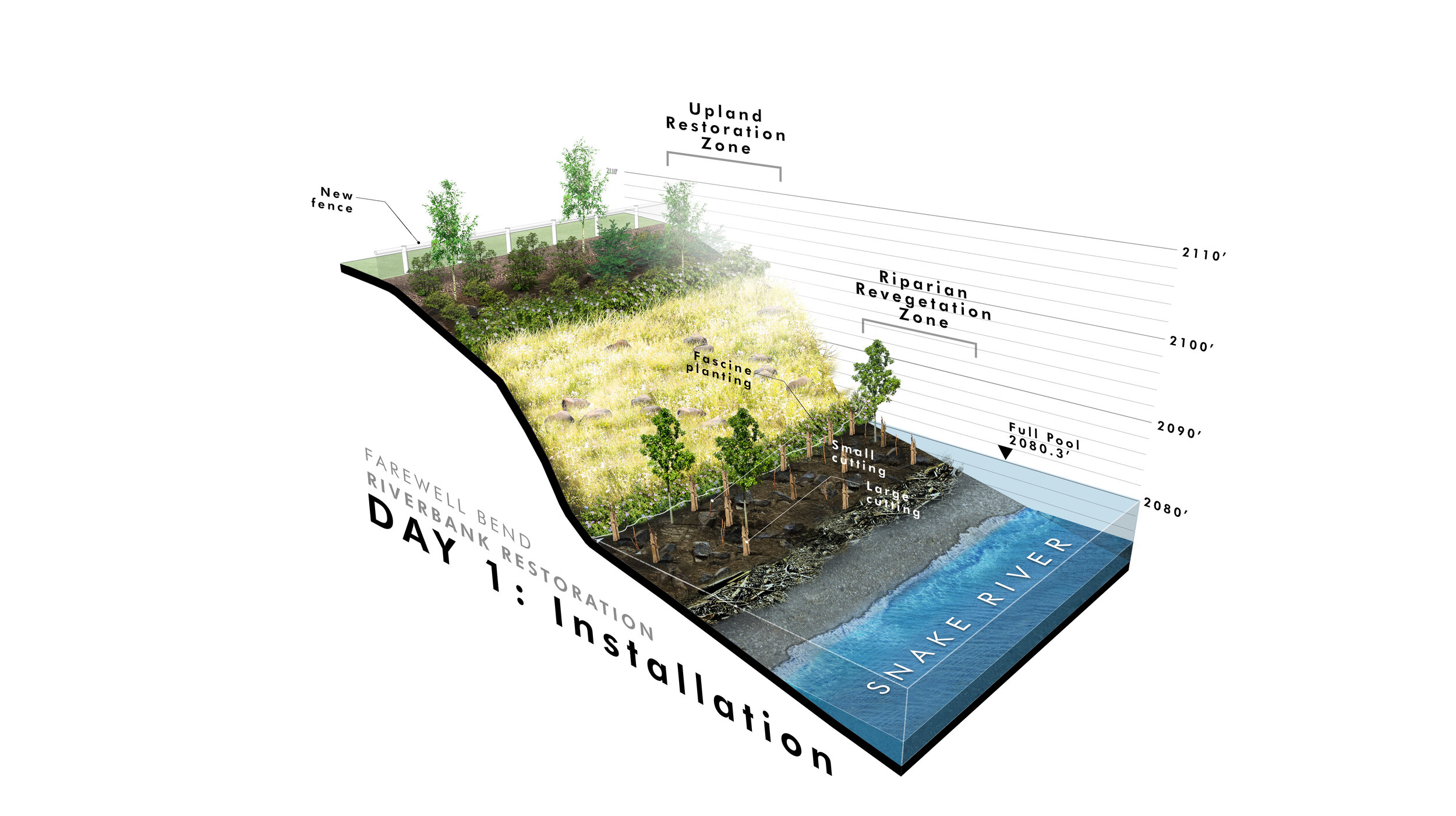
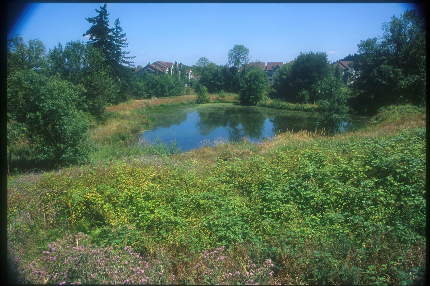
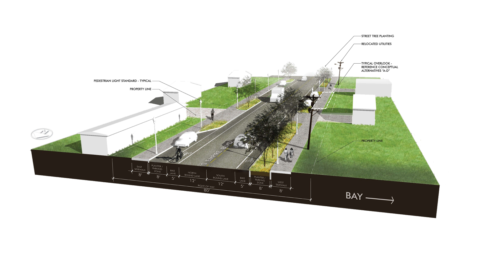
In November of 2014 GreenWorks began a site assessment and preliminary design for the Johnson Creek Oxbow Enhancement Project. The central feature of the site is the namesake “Oxbow” meander, which is bounded on the south by a bypass channel that truncates the oxbow creating an island. The by-pass channel was constructed by the Works Progress Administration (WPA) in the 1930’s and included armoring the creek bed and banks, and creating a fish ladder in the oxbow to maintain fish passage. The goal of the WPA work was to convey flood flows efficiently downstream. It resulted in a confined channel, which is hydrologically disconnected from adjacent floodplains and wetlands, and exacerbates flooding. GreenWorks was charged with providing design strategies for improving floodplain hydrology, riparian and in-stream habitat, and local flood impacts.


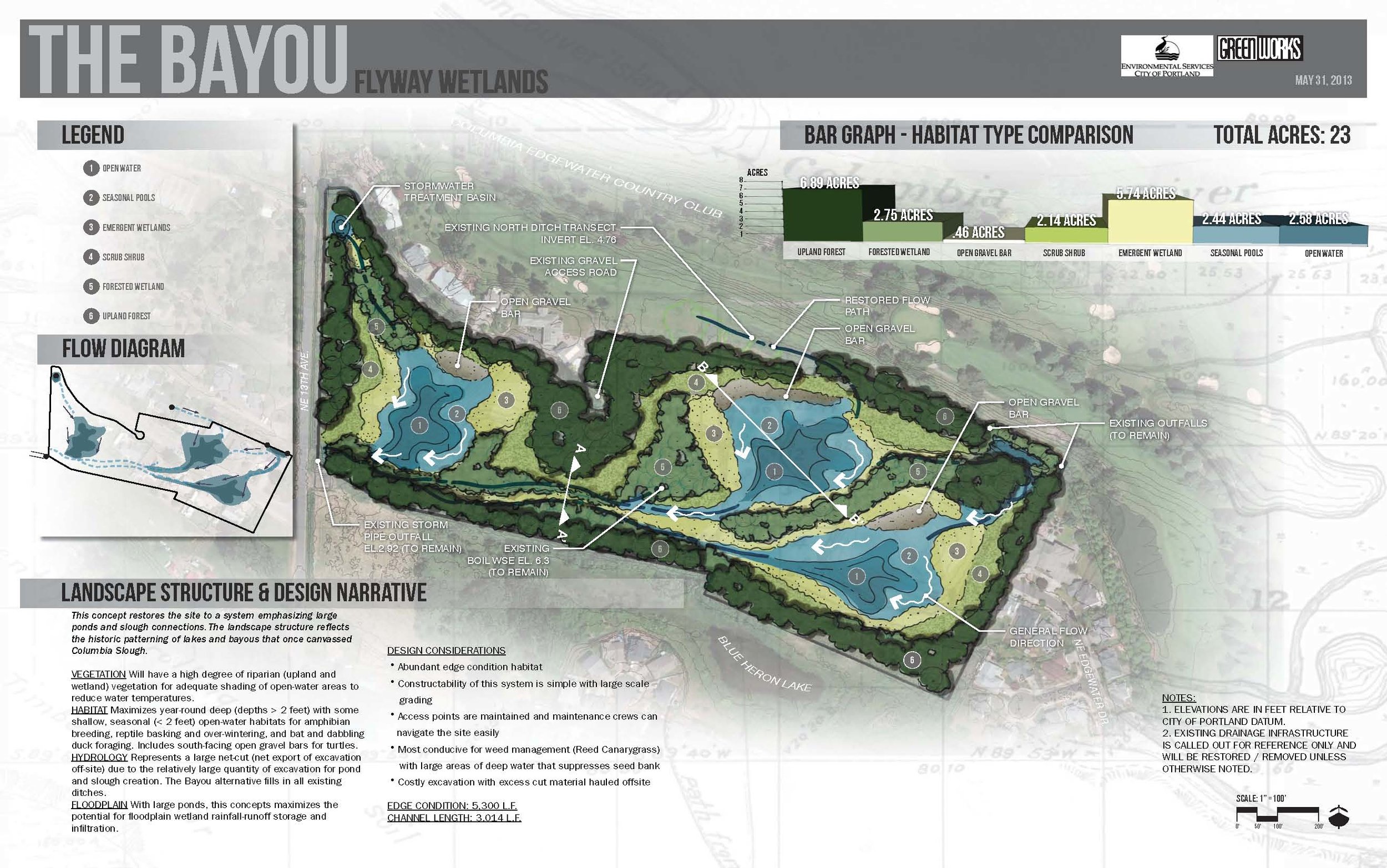
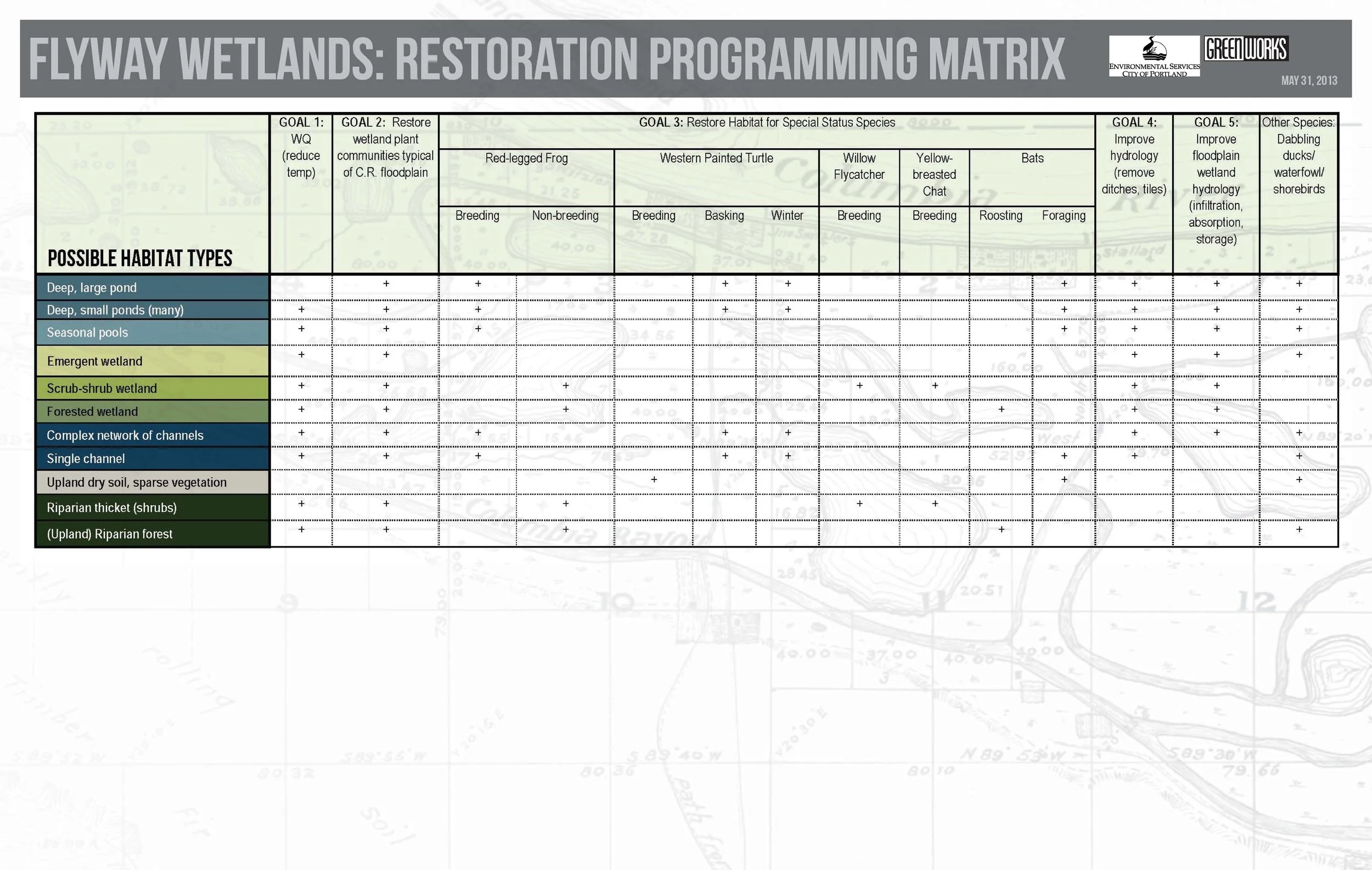
To support these goals, GreenWorks held a one day charrette, which included members from BES, ESA-Vigil Argimis, and KPFF to discuss and recommend a variety of design strategies for improving the inherent conditions found within the Johnson Creek Oxbow. Recommendations were collected and vetted amongst the consultants and further discussed with BES to determine a set of design alternatives for specific sites within the project area. Project sites were mapped, along with support graphics and images, and cost-estimates, to BES in a comprehensive Pre-Design report, thus allowing BES to prioritize future improvement projects for the Johnson Creek Oxbow area.

BES_Oxbow_Perspective.jpg

BES Flyway Wetlands Enhancement

GreenWorks provided landscape architecture services for Portland’s Bureau of Environmental Services Flyway Wetland property located between the Columbia Slough and the Columbia River near the Portland airport. GreenWorks led a team to provide several wetland restoration concepts and a wetland delineation report. GreenWorks headed several workshops with the consultant and team to develop the preferred concepts based on goals for the project including: water quality improvement; vegetation and habitat restoration; wetland hydrology improvement; and floodplain wetland hydrology improvements. Wetland and Stream Delineation Reports and Wetland Restoration Concepts were created for internal analysis related to bureau’s goals for restoring the site and their overarching restoration goals for bureau’s environmental group.

Flyway_Wetlands_Sections_Mosaic.jpg
Flyway_Wetlands_Sections_Bayou.jpg
Flyway_Wetlands_Plan_Concepts_Mosaic.jpg
Flyway_Wetlands_Plan_Concepts_Bayou.jpg
Flyway_Wetlands_Design_Concept_Table.jpg
flyway (5).jpg
flyway (1).jpg

BES Columbia Slough Stormwater Retrofit Inventory

In January 2010, GreenWorks and BES staff conducted intensive field work locating and documenting potential locations for stormwater facilities throughout the Columbia Slough Watershed in North Portland. The Columbia Slough has been designated a high priority area by the City of Portland for improving watershed health and reducing pollutants. The project team focused on four target areas where green street facilities would maximize stormwater quality treatment and capture contaminated sediment before being discharged into the Slough. Each potential green street facility was ranked based on its potential performance, feasibility, and cost. GreenWorks assisted BES in project prioritization and provided an overall ranking using Geographic Information Systems (GIS). Over 150 potential green street facilities were identified, which would potentially result in stormwater treatment from over 35 acres of impermeable surfaces.

Columbia Slough Project Prioritization.jpg
Overall Map_Labels.jpg
Target Areas.jpg

Albany Stormwater Standards

Albany_Stormwater3.jpg

GreenWorks has worked over the past several years with City of Albany staff to develop stormwater quality standards for development to meet DEQ regulatory requirements.  The products include new and  updated sections of City Administrative Codes, Development Codes, Engineering Standards, Standard Construction Specifiations, and Standard Drawings.   The draft products are currently in the public review process, with adoption and implementation tentatively planned by the end of 2014.  Draft documents are all available for review on the City of Albany/Public Works/Engineering web page.

Streetside_Shallow_Swale.jpg
Albany_Stormwater_illustrations.jpg
Albany Stormwater.jpg

Central City Concern's Madrona Studios

The Madrona Lofts in the Rose Quarter of Portland offered a tremendous opportunity to rehabilitate an older hotel into much needed housing complex. GreenWorks was part of a team of designers that analyzed the existing facilities and surrounding development for opportunities to improve both the project site and the pedestrian connections from the community, through the site, to the adjacent Rose Garden. 

Applying a number of sustainable site design practices, GreenWorks provided designs focused on developing meaningful pedestrian spaces and strengthening pedestrian connections to the surrounding developments.

DSC_0084.JPG

Empire Boulevard

The City of Coos Bay received federal funding to install bike lanes, landscape strips, and sidewalks to Empire Boulevard between Newmark Avenue and Wisconsin Avenue to provide alternative transportation opportunities along this heavily traveled corridor.

Improvements include widening the existing two-lane road to make room for on-street parking and bike lanes, installing curb, gutter, landscape strips with street trees, and sidewalk on both sides of the road. Stormwater / water quality facilities are constructed to manage stormwater on-site, converting Empire Boulevard into a ‘green street’. Other project elements include interpretive overlooks with site furniture, illumination, signing, striping, and numerous driveway connections.

Empire Blvd Coos Bay.jpg

Tryon Creek State Park Friends Circle

GreenWorks participated in a series of volunteer design sessions, focused on improving the entry, arrival sequence and wayfinding for visitors to SW Portland’s Tryon Creek State Park.

Friends Circle_1.jpg

GreenWorks participated in a series of volunteer design sessions, focused on improving the entry, arrival sequence and wayfinding for visitors to SW Portland’s Tryon Creek State Park. In concert with Fletcher Farr Ayotte Architects, we assisted in evaluating existing circulation patterns for pedestrians, bicyclists and drivers who access and use the park. The result of this effort was a series of site planning and design recommendations to both Oregon Parks and Recreation Department staff and the Friends of Tryon Creek.

7067_Plaza_Concept - Copy.jpg
Sign_OptionA_Color.jpg

Human Access Project

With the completion of the Big Pipe in 2011, water quality in the Willamette has improved by leaps and bounds. In the wake of this achievement, Will Levenson, head of the non-profit Human Access Project, is leading an effort to change people’s perceptions of the river and encourage recreation in the water and along the waterfront.
GreenWorks became involved in the Human Access Project in November 2012, bringing our extensive experience designing places for people within sensitive natural environments, which focus on balancing access with habitat conservation.
This balance is certainly a key consideration as the Human Access Project gains momentum through additional community outreach and scaled interventions along the Willamette’s shores. Greenworks is honored to be contributing to this worthy cause and looks forward to witnessing the transformation of Portland’s largest public open space in the years to come.